Andes and Cordillera Real
The Cordillera Real is a mountain range in the South American Altiplano of Bolivia. This range of fold mountains, largely composed of granite, is located southeast of Lake Titicaca, and east of the Bolivian capital of La Paz, measuring 125 km in length and 20 km in width. Despite the fact that it is only 17° south of the Equator, the Cordillera Real is relatively densely glaciated. This is due to its proximity to the Amazon lowlands with its associated moist air masses.
Illimani Mountaine
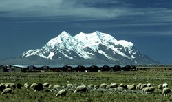
Illimani is the highest mountain in the Cordillera Real (part of the Cordillera Oriental, a subrange of the Andes) of western Bolivia. It lies just south of La Paz at the eastern edge of the Altiplano. It is the second highest peak in Bolivia, after Nevado Sajama, and the eighteenth highest peak in South America. The snow line lies at about 4,570 metres (15,000 ft) above sea level, and glaciers are found on the northern face at 4,983 m (16,350 ft). The mountain has four main peaks; the highest is the south summit, Nevado Illimani, which is a popular ascent for mountain climbers.
Huayna Potosi
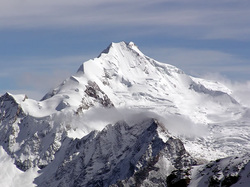
Huayna Potosí is the closest high mountain to La Paz, a city which is surrounded by high mountains, and itself is the highest capital city in the world. Huayna Potosí is roughly fifteen miles due north of the city, which makes this mountain the most popular climb in Bolivia. The normal ascent route is a fairly straightforward glacier climb, with some crevasses and a steep climb to the summit. However, the other side of the mountain, Huayna Potosí West Face, is the biggest face in Bolivia. Several difficult snow and ice routes goes up this 1000 meter high face.
The first ascent of the normal route took place in 1919 by Germans Rudolf Dienst and Adolf Schulze. Some climbing books report this mountain as the "easiest 6000er in the world", but this claim is arguable. The easiest route entails an exposed ridge and sections of moderately steep ice, with a UIAA rating of PD. There are many 6000m mountains that are easier to climb in terms of technical difficulty. Perhaps, the main reason Huayna Potosí has been called the easiest 6000m climb is that the elevation gain from trailhead to summit is less than 1400 m; with easy access from La Paz. Since La Paz is at 3640 m, climbers have an easier time acclimatizing.
The first ascent of the normal route took place in 1919 by Germans Rudolf Dienst and Adolf Schulze. Some climbing books report this mountain as the "easiest 6000er in the world", but this claim is arguable. The easiest route entails an exposed ridge and sections of moderately steep ice, with a UIAA rating of PD. There are many 6000m mountains that are easier to climb in terms of technical difficulty. Perhaps, the main reason Huayna Potosí has been called the easiest 6000m climb is that the elevation gain from trailhead to summit is less than 1400 m; with easy access from La Paz. Since La Paz is at 3640 m, climbers have an easier time acclimatizing.
Illampu
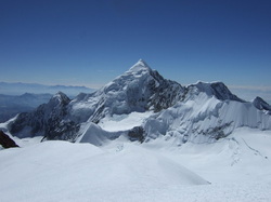
Illampu is the fourth highest mountain in Bolivia. It is located in the northern section of the Cordillera Real, east of Lake Titicaca. It lies just north of the slightly higher Janq'u Uma, near the town of Sorata. Laguna Glaciar, located in the Illampu-Janq'u Uma massif, is the 17th highest lake in the world.
Despite being lower than Janq'u Uma, Illampu has a steeper peak, with more local relief, and is a somewhat harder climb. In fact it has the hardest normal route on any of the 6,000 metre peaks in Bolivia. The easiest route, by the Southwest Ridge, is rated AD (Fairly Difficult), with snow slopes up to 65 degrees. It is accessed from a high camp on the north side of the massif.
Despite being lower than Janq'u Uma, Illampu has a steeper peak, with more local relief, and is a somewhat harder climb. In fact it has the hardest normal route on any of the 6,000 metre peaks in Bolivia. The easiest route, by the Southwest Ridge, is rated AD (Fairly Difficult), with snow slopes up to 65 degrees. It is accessed from a high camp on the north side of the massif.
Sajama
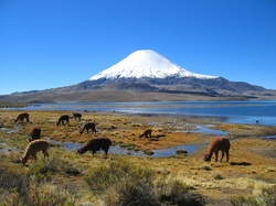
Nevado Sajama is an extinct stratovolcano and the highest peak in Bolivia. The mountain is located in the Oruro Department, Sajama Province, Cuarahuara de Carangas Municipality, Sajaman Canton. It is situated in the Sajama National Park in the southwest area of the country some 16–24 km (10-15 mi) from the border with Chile. The peak is an isolated cone, but is geologically complex.. The date of the most recent eruption is uncertain, although Holocene activity is assigned to the volcano by many. The treeline of the volcano is as high as 5,200 m above sea level, one of the highest altitudes trees can be found growing anywhere in the world.
